Micanopy Cycling
Wacahoota Route

Over 75 and Through the Hills...
The Wacahoota route is deceptively difficult. At 6 miles one-way, it is one of the longer routes described here. Also, it has two large hills that are stacked back-to-back. Ok, one of them isn’t so much a hill as it is a highway overpass, but it makes your legs feel just as tired. Once you are over the hills it’s pretty smooth sailing to the Wacahoota neighborhood, which is sprawling and quiet. The good news is, you get to climb the hills again on your way back! Yay!
Route Highlights
Paynes Prairie Main Entrance
The main entrance to Paynes Prairie Preserve State Park is just up around the bend from Micanopy.
Lake Wauberg
This is a particularly useful place to note if you are going biking on a hot day…and are a UF student. The lake, complete with volleyball courts, boat rentals and a dock, is only open to those either affiliated with the university or with someone who is.
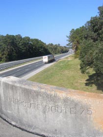
I-75 Overpass
I don’t have a “lowlights” section. The middle of this bridge may be the highest point of elevation on any of the journeys I write about, so it’s got that going for it.
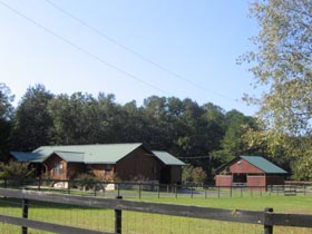
Strange Home
I don’t know what this building is, whether it is a home or a firehouse inspired by Play-Doh, I don’t know, but it’s definitely different.
Wacahoota Neighborhood
Take a peaceful cruise through this neighborhood of expensive homes on large wooded lots.
Route Directions
1. Take Cholokka Blvd North to US-441 -- 0.4 mi
The road is nicely shaded here and riders can watch the beautiful little town of Micanopy pass by before they reach 441.
2.Turn left at US-441 -- 1.6 mi
This is not as pretty a stretch of road. Cars go flying past you along 441, particularly after the bend where the speed limit jumps up to 65 mph. Of course, in Florida that generally means 75 mph. There is not much shade either since the roadway is very wide. However, the road does have a few good points. The pavement is very good, probably since there is so much high speed traffic. Also, if you go North from Micanopy, the shoulder on 441 is quite wide, about five feet. So although the traffic can get a little hot and heavy, it shouldn’t get too close. That’s a good thing in this instance.

3.Turn left at SE Wacahoota Rd. -- 2.9 mi
One of the nice things about this route is there is actually some terrain. Ok, not much but by Florida standards it is positively mountainous. Turn left onto Wacahoota Road just as the road starts to slope down toward Lake Wauberg. Instead of a downslope, bikers get to climb up a bridge. At the top riders can look down on one of the many unnatural wonders that traverse the state, the river of cars and trucks churning up and down I-75. There’s a few more hills, one good one along the way to the next turn. Watch out for deer and lazy dogs on the way.
4. Turn Right on SW 16 St. Ride until Dead End -- 1.0 mi
Turn into this neighborhood of large attractive homes with larger more attractive yards. Some of the homes are carefully landscaped while others utilize their acreage for raising donkeys, horses and cattle (I’m pretty sure I came upon a Brahmin cow here once, which is a bit different). The road is wide and nice, there’s no traffic and the environment is as relaxing as it gets. Even the not-so-distant rush of traffic on I-75 is transformed into the calming, rhythmic whooshes of wind here.
One Way: 6 miles
Round Trip: 12 miles
Travel Time: 35-45 minutes one way
- Home | Tuscawilla | Southeast Micanopy | Evinston | Lochloosa | Shiloh | Wacahoota | Paynes Prairie | Eco Passage | Rochelle | Contact Me
View Wacahoota in a larger map