Micanopy Cycling
Southeast Micanopy Route

Dodge Bulls and Bugs on the South Side of Micanopy
A short little 4-mile circuit, this ride is particularly good for people just starting out or who haven’t ridden in a while. Almost the entire route is on quiet back roads. Although this is the shortest of the routes, it packs a punch with two notably steep hills on the back side and a number of other slopes interspersed throughout. The short stretch along I-75 is not the most attractive ride in the world, but it is different. Look for the nice house on a hill with a huge billboard in the front lawn.
Route Highlights
Wendy’s House
This lady is a character. Just look at her house. Apparently she has a thing for the colors pink and blue. She also apparently never met a lawn ornament she didn’t like. Whoa.
Tuscawilla Preserve
The Tuscawilla Preserve is a small sea of tall grasses. The walking area across from the Native American Heritage Preserve is nicely shaded and has a few picnic tables for visitors. A few different areas of the prairie-like environment will be covered in water during the winter months.
Micanopy Cemetery
For some reason the pet cemetery makes me sadder than the human cemetery. The Micanopy cemetery was established in 1821 and it is very easy to find a bunch of headstones whose owners were born in the 19th century, as well as a few here and there that died in the 1800s. It’s really beautiful in the early spring when the azaleas and dogwoods are blooming.
Route Directions
1. Head west on Seminary Ave for 0.7 miles.
Take Seminary Avenue away from the Old Florida Café. About three houses down you will pass one of the most amazing all-year yard displays I’ve ever seen. Clark Griswold ain’t got nuttin’ on this lady.

2. Turn left at Co Rd 234 and ride 0.4 miles.
Watch out for some semi-tractor traffic on this short little stretch. The road seems to have a higher than normal amount of semis, perhaps because of the proximity of US-441 and I-75 (or the proximity of Café Risque…). Jog left onto the dirt road just as 234 starts to curve around to the right.
3. Take the 2nd left onto SE 26 St. Go straight for 1.1 miles.
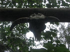
While this dirt road doesn’t have the large wide open vistas of some of the other roads on this list, it does still have some interesting sights, like the house with the cattle skull fastened to the entryway or the large, attractive looking home with a huge Modern Age Tobacco Shop Billboard in the front yard. You’ll have to go up a bit of a hill as the trees fall away on your right and reveal the irritating presence of I-75.
4. Head east around the bend onto SE 185 Ave for 0.6 miles.
Just as the road turns to the left away from 75, the bottom falls out. It’s a good idea to try to keep up your speed here as you are going to have an equally large hill to climb back up immediately after the one you are racing down. You’ll go down another less steep hill but you’ll need to turn left before you get to the bottom this time.
5. Take the 1st left onto Whiting Rd and continue for 1.4 miles.
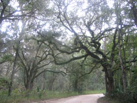
Big old trees dripping with Spanish moss abound here. The road starts out with a long, lazy downslope and then has a short, mean little hill about halfway to your next turn. The last third of this road is paved, but there’s a few big, nasty speed bumps thrown in.
6. Turn right at Smith Ave and ride 436 feet.
The church right on the corner of Whiting and Smith had served the Baptist community here since the 1880s but it is now a private residence. Also, the distinctive brick wall on the left marks the bounds of the former Montgomery estate. It has also stood since the turn of the twentieth century. To get back to Cholokka you have to turn right and go around the bend to the left and turn right again on Ocala. But, if you turn left and peddle past a couple of houses you’ll come upon the Micanopy Cemetery, established in 1821, which is very pretty.
7. Take the 1st right onto Ocala Ave and continue for 0.1 miles.
Head down the home stretch past the Council Oaks and mayor’s home on the right.
Round Trip: 4.4 miles
Travel Time: 25-30 minutes
- Home | Tuscawilla | Southeast Micanopy | Evinston | Lochloosa | Shiloh | Wacahoota | Paynes Prairie | Eco Passage | Rochelle | Contact Me
View SE Micanopy in a larger map