Micanopy Cycling
Tuscawilla Preserve Route

Around the Prairie Lake
This 5-mile plus route circles around the Tuscawilla Preserve, a wide-open grassy plain. The first leg runs down to 441 past a nice walking area along the edge of the preserve. While the route does call for you to ride along 441, it is only a short way to the turn off. The road slopes upward for about a half a mile after you turn. However, once you are over that hill the rest of the way is mostly downhill and traffic-free back roads, so push on!
Route Highlights
Micanopy Native American Heritage Preserve
The preserve is pretty much just a couple of paths meandering through the woods, but it’s still nice. Quite a bit of progress has been made in the last couple of months, including the clearing of more paths and steps towards the opening of the little museum.
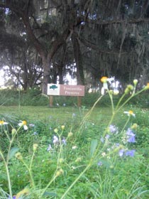
Tuscawilla Preserve
The Tuscawilla Preserve is a small sea of tall grasses. The walking area across from the Native American Heritage Preserve is nicely shaded and has a few picnic tables for visitors. A few different areas of the prairie-like environment will be covered in water during the winter months.
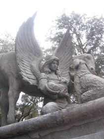
Garden of Love Pet Memorial Cemetery
Must of this hilly wooded area is empty. The rest is pretty and peaceful if a little sad.
Micanopy Cemetery
For some reason the pet cemetery makes me sadder than the human cemetery. The Micanopy cemetery was established in 1821 and it is very easy to find a bunch of headstones whose owners were born in the 19th century, as well as a few here and there that died in the 1800s. It’s really beautiful in the early spring when the azaleas and dogwoods are blooming.
Route Directions
1. Take Tuscawilla Rd. East for 0.9 miles to US-441.
Go down the hill just past where the road curves into Tuscawilla at the end of Cholokka. About 2/3 the way to 441 you’ll come upon the Micanopy Native American Heritage Site on the left and the Tuscawilla Preserve on the right. Both are nice quiet places.
2. Turn right onto US-441. Head South for 0.7 miles.
I am not a fan of riding along 441, particularly south of Micanopy. The shoulder is narrower south of Micanopy than it is north of town, but the cars whip by just as fast. Tuscawilla Preserve will open up on your right as you head south. There is often a herd of Hereford cattle near the fence here. Also, about half a mile after you turn, there is a pet cemetery on the left-hand side of the road, but you have to cross over the median to get there.
3. Take the 1st right onto Veterans Way and continue for 0.2 miles.
Jog right onto Veterans Way just as 441 starts to climb a hill. There’s a couple of nice houses back here but no cars, a welcome change from the highway.

4.Slight right at SE 59 St and go straight for 0.6 miles.
Just as Veterans starts to curve back toward 441 (it’s really short), a dirt road spurs off to the right. Take that road up the hill and coast down the other side to the next turn.
5. Turn right at SE 185 Ave/NW 230th St. Go for 1.3 miles.
Turn right at the bottom of the hill. Be careful here. It’s basically a blind corner and cars occasionally come tearing down this road from 441. You are now on the other side of the Tuscawilla Preserve, which you can occasionally get glimpses of. Again, there’s some really nice houses/farms/complexes around here to look at, as well as a little lake on this side of the prairie.
6. Turn right at Whiting Rd and continue for 1.4 miles.
Just when the road starts to be paved, turn right onto Whiting. Big old trees dripping with Spanish moss abound here. The road starts out with a long, lazy downslope and then has a short, mean little hill about halfway to your next turn. The last third of this road is paved, but there’s a few big, nasty speed bumps thrown in.
7. Turn right at Smith Ave, 436 ft.
The church right on the corner of Whiting and Smith had served the Baptist community here since the 1880s but it is now a private residence. Also, the distinctive brick wall on the left marks the bounds of the former Montgomery estate. It has also stood since the turn of the twentieth century. To get back to Cholokka you have to turn right and go around the bend to the left and turn right again on Ocala. But, if you turn left and peddle past a couple of houses you’ll come upon the Micanopy Cemetery, established in 1821, which is very pretty.
8. Take the 1st right onto Ocala Ave, 0.1 miles.
Head down the home stretch past the Council Oaks and mayor’s home.
9. Take the 1st left onto Cholokka Blvd.
Round Trip: 5.3 miles
Travel Time: 25-30 minutes
- Home | Tuscawilla | Southeast Micanopy | Evinston | Lochloosa | Shiloh | Wacahoota | Paynes Prairie | Eco Passage | Rochelle | Contact Me
View Tuscawilla in a larger map