Micanopy Cycling
Shiloh Route

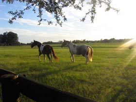
The Horse Farms of Shiloh
Route Highlights
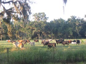
Of all of the routes, this one is my favorite. At 13.6 miles, it is also the longest. But it’s worth it! The route runs up and down hills, far away from cars and into the domain of bulls, bucks and bears (ok, maybe not bears). Honestly, almost the entire route runs along farms or ranches raising all kinds of different animals, from turkeys to goats to cattle. If only every ride could be like the stretch running along the beautiful horse farms of Shiloh. Long, black wooden fences, a rolling green horizon, and stamping, galloping beasts, it’s enough to make you forget everything else. Most of the way is paved, although there is a short hilly stretch on a rutted dirt road.
Wendy’s House
This lady is a character. Just look at her house. Apparently she has a thing for the colors pink and blue. She also apparently never met a lawn ornament she didn’t like. Whoa.
Café Risque
Unfortunately, for the longest time, I thought Café Risque was Micanopy. It is the point of origin for all of those “We Bare All” signs you see on I-75 while also being a sort of black hole, sucking in truckers, college kids, and young girls’ innocence.
Shiloh
Shiloh claims to be a place but I haven’t found any particular center of gravity around which the town orbits. I’m not sure I’ve even noticed that the density of homes is any higher here. What I can say is I’ve passed a green sign on the side of the road a couple of times that says “Shiloh”.
Mt. Pedro Cemetery
This tiny little cemetery is down a grassy hill and around a fence behind someone’s yard. Seriously. There’s not a road running to it, there is a grassy hill. It is tiny, as you might expect, but still seems to have an understated dignity about it.
Frontier Homes (?)
Along NW Hwy 320 there are three small buildings all lined up next to each other along a hill. I’m not sure what they are (or rather, were) but it seems that they are being preserved for some reason. While they are not exactly being renovated, someone did take the time to put up “No Trespassing” signs on them and hasn’t seen fit to knock them down, anyway.
Deerfield Farm
This farm has been in the family since the 1840s. On the first weekend of December you can go into the farm and watch sugar cane being fed into a restored vintage Chattanooga No. 72 mill.
Route Directions
1. Take Seminary Ave west for 0.7 miles to Co Rd 234.
Take Seminary Avenue away from the Old Florida Café. About three houses down you will pass one of the most amazing all-year yard displays I’ve ever seen. Clark Griswold ain’t got nuttin’ on this lady.
2. Turn left at Co Rd 234 and ride for 1.5 miles.
Pass by Café Risque (if you’ve driven on I-75, you’ve probably heard of it) and under the highway and off into the wild. Ok, not really, but away from highways and strip clubs anyway. Before you go up the hill you’ll pass a large plot of land on the right that is often dotted by cows and turkeys. A smaller farm on the left raises goats.
3. Continue onto SE 175 Ave for 1.4 miles.
As you crest the hill you’ll be given two options. I recommend taking the dirt road fork on the right on the way out so you can take the paved road on the way in, when you are more likely to be tired. The beginning of this dirt road all the way to the top of the next hill tends to be pocked by potholes or little moguls, which can be annoying. The dirt road levels out after that until you get to the Marion County line.

4. Continue onto NW 221st Street Rd for 2.1 miles.
When you hit the county line the road turns into a paved-downhill chute (it also changes name). The tree line gives way onto a wide open vista of rolling hills on the left. This road is so quiet it almost seems like you are riding along someone’s private driveway.
5. Turn left at NW Hwy 320 for 3.0 miles.
This road is more heavily trafficked than the last, although not to any great extent. The road winds past horse farms lined by black wooden fences stretching into the distance. This road will carry you within the bounds of the “town” of Shiloh, although I have yet to find anything differentiating this area from the surrounding nameless pastures. As you near the next turn, on the left as you pass will be three small, crumbling structures on stilts marked with “no trespassing” signs. I’m not sure what they are but they seem as though they are being preserved for future restoration or something. Interesting anyhow.
6. Turn left at N Hwy 329 / Co Rd 234 and continue 4.2 miles
Go down the hill to the left to head home. However, if you turn right and go just to the top of the hill you’ll come upon a small sign nailed to a tree on the right. The sign points down a grassy hill towards the Mt. Pedro Cemetery, which is seemingly tucked into a local’s backyard. Back towards home, the road passes by a number of beautiful lots and up and down a few hills. You will cross back over the county line and the name will change back to Co Rd 234. I’ve seen a number of deer loping away from me on both this road and Hwy 320.
7. Turn right at NW Seminary Ave and go straight for 0.7 miles
Turn onto Seminary to head back home.
Round Trip: 13.6 miles
Travel Time: 65-75 minutes
- Home | Tuscawilla | Southeast Micanopy | Evinston | Lochloosa | Shiloh | Wacahoota | Paynes Prairie | Eco Passage | Rochelle | Contact Me
View Shiloh Route in a larger map