East Gainesville Master Plan


 The objective of this studio was to understand the influence of context in decision-making; to explore principles of landscape ecology and their influence on design decision-making; and to explore land use conventions and Florida regulations and their influence on design decision-making. The studio introduced students to decision-making at the regional scale (Alachua County and larger) and at the urban/rural scale (east Gainesville) through the application of design and planning using Geogaphical Information Systems (GIS) technology.
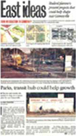
East Gainesville, an economically depressed area of the city and county, is currently the focus of several planning efforts to stimulate growth and economic vitality. These efforts involve the City, County and local residents. University of Florida faculty and students from the Department of Landscape Architecture became partners in this effort during the 2001 fall semester, developing alternatives for future development and conservation for this area of the City and County. The University of Florida study will serve as a kick off on January 31, 2002 for the Plan East Gainesville effort undertaken by City and County through their Metropolitan Transportation and Planning Organization.
The result of this planning and design studio present various scenarios for development and conservation for the study area. The desire from all the stake holders is that East Gainesville develop and grow differently than the western side of town, an area plagued with sprawl. Consequently, all the studio proposals integrated transportation planning with land use planning. Students explored opportunities to develop much needed neighborhood oriented mixed-use nodes in conjunction with new transportation hubs. Proposals looked at the protection and enhancement of existing residential neighborhoods that have a strong social fabric, and proposals for addressing the deficiencies in blighted residential areas.
An important component of all the proposals are the conservation plans since the study area is unique in its high percentage of wetlands and areas of special environmental concern. The proposed conservation area plans function as important wildlife corridors at a regional scale, and the proposed network of trails function as important ways for residents and visitors to move throughout the city. This allows for connection to popular recreational resources, and helps promote nature-based tourism in the area. By protecting these environmental assets, this area will be able to maintain better ecological integrity and retain its unique sense of place.
UF Department of Landscape Architecture: LAA 4352 Fall 2001


