Europe
 Europe is one of the seven continents of the Earth. Physically and geologically, Europe is the westernmost peninsula of Eurasia, west of Asia. Europe is bounded to the north by the Arctic Ocean, to the west by the Atlantic Ocean, to the south by the Mediterranean Sea, and to the southeast by the waterways adjoining the Mediterranean to and including the Black Sea and the Caucasus Mountains. On the east, Europe is divided from Asia by the water divide of the Ural Mountains and by the Caspian Sea.
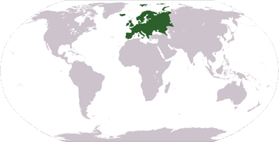
Europe is the world's second-smallest continent in terms of area, covering about 10,400,000 square kilometres (4,010,000 sq mi) or 2.0% of the Earth's surface. The only continent smaller than Europe is Australia. In terms of population, it is the third-largest continent (after Asia and Africa) with a population of some 710,000,000 or about 11% of the world's population. However, the term continent can refer to a cultural and political distinction or a physiographic one, leading to various perspectives about Europe's precise borders, area, and population.
The European Union – comprising 25 member states, with two countries acceding in 2007 (Bulgaria and Romania) and two candidates in accession negotiations (Turkey and Croatia) – is the largest political and economic entity covering the European continent, while Russia (excluding portions in Asia) is the second largest entity and Europe's largest state in area and population.
Physiographically, Europe is the northwestern constituent of the larger landmass known as Eurasia, or Africa-Eurasia: Asia occupies the eastern bulk of this continuous landmass (save the Suez Canal separating Asia and Africa) and all share a common continental shelf. Europe's eastern frontier is now commonly delineated by the Ural Mountains in Russia (Strabo, Geography 11.1, took the Tanais River to be the boundary, as did early Judaic sources). The south-east boundary with Asia is not universally defined. Most commonly the Ural or, alternatively, the Emba River serve as possible boundaries. The boundary continues to the Caspian Sea, the crest of the Caucasus Mountains or, alternatively, the Kura River in the Caucasus, and on to the Black Sea; the Bosporus, the Sea of Marmara, and the Dardanelles conclude the Asian boundary. However, numerous geographers consider Azerbaijan's and Armenia's southern border with Iran and Turkey's southern and eastern border with Syria, Iraq and Iran as the boundary between Asia and Europe because of political and cultural reasons. The Mediterranean Sea to the south separates Europe from Africa. The western boundary is the Atlantic Ocean; Iceland, though nearer to Greenland (North America) than mainland Europe, is generally included in Europe. There is ongoing debate on where the geographical centre of Europe is. For detailed description of the boundary between Asia and Europe see here.
Due to sociopolitical and cultural differences, there are various descriptions of Europe's boundary; in some sources, some territories are not included in Europe, while other sources include them. For instance, geographers from Russia and other post-Soviet states generally include the Urals in Europe while including Caucasia in Asia.
In another usage, Europe is increasingly being used as a short-form for the European Union (EU) and its members, currently consisting of 25 member states and the candidate countries negotiating for membership, and several other countries expected to begin negotiations in the future (see Enlargement of the European Union). This definition, however, excludes non-members such as Switzerland, Norway and Russia.
Geography
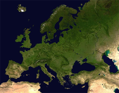 Europe is traditionally reckoned as one of seven continents. Physiographically, however, it is the northwestern peninsula of the larger landmass known as Eurasia (or Africa-Eurasia): Asia occupies the eastern bulk of this continuous landmass (save the Suez Canal separating Asia and Africa) and all share a common continental shelf. Europe's eastern frontier is delineated by the Ural Mountains in Russia. The south-east boundary with Asia is not universally defined. Most commonly the Ural or, alternatively, the Emba River serve as possible boundaries. The boundary continues to the Caspian Sea, the crest of the Caucasus Mountains or, alternatively, the Kura River in the Caucasus, and on to the Black Sea; the Bosporus, the Sea of Marmara, and the Dardanelles conclude the Asian boundary. However, numerous geographers consider Azerbaijan's and Armenia's southern border with Iran and Turkey's southern and eastern border with Syria, Iraq and Iran as the boundary between Asia and Europe because of political and cultural reasons. The Mediterranean Sea to the south separates Europe from Africa. The western boundary is the Atlantic Ocean; Iceland, though nearer to Greenland (North America) than mainland Europe, is generally included in Europe. There is ongoing debate on where the geographical centre of Europe is. For detailed description of the boundary between Asia and Europe see here.
The idea of a European "continent" is not universally held. Some non-European geographical texts refer to a Eurasian Continent, or to a European "sub-continent", given that "Europe" is not surrounded by sea and is, in any case, much more a cultural than a geographically definable area.
The two largest of these are "mainland" Europe and Scandinavia to the north, divided from each other by the Baltic Sea. Three smaller peninsulas—Iberia, Italy and the Balkans—emerge from the southern margin of the mainland into the Mediterranean Sea, which separates Europe from Africa. Eastward, mainland Europe widens much like the mouth of a funnel, until the boundary with Asia is reached at the Ural Mountains.
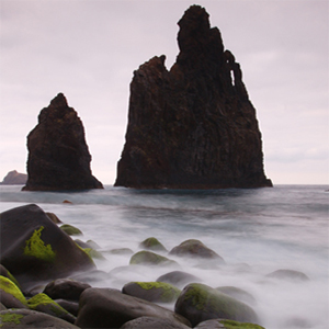
Land relief in Europe shows great variation within relatively small areas. The southern regions are mountainous, while moving north the terrain descends from the high Alps, Pyrenees and Carpathians, through hilly uplands, into broad, low northern plains, which are vast in the east. An arc of uplands also exists along the northwestern seaboard, beginning in the western British Isles and continuing along the mountainous, fjord-cut spine of Norway.
This description is simplified. Sub-regions such as Iberia and Italy contain their own complex features, as does mainland Europe itself, where the relief contains many plateaus, river valleys and basins that complicate the general trend. Iceland and the British Isles are special cases. The former is a land unto itself in the northern ocean which is counted as part of Europe, while the latter are upland areas that were once joined to the mainland until rising sea levels cut them off.
The few generalizations that can be made about the relief of Europe make it less than surprising that the continent's many separate regions provided homes for many separate nations throughout history.
-wikipedia.org
Australia | Home | North America