Amazonia 1492: Pristine Forest or Cultural Parkland?
Michael J.
Heckenberger,1*
Afukaka Kuikuro,4 Urissapá Tabata
Kuikuro,4 J. Christian
Russell,2 Morgan Schmidt,3
Carlos Fausto,5 Bruna
Franchetto5
Archaeology and indigenous history of Native Amazonian
peoples in the Upper Xingu region of Brazil reveal
unexpectedly complex regional settlement patterns and
large-scale transformations of local landscapes over the
past millennium. Mapping and excavation of archaeological
structures document pronounced human-induced alteration
of the forest cover, particularly in relation to large,
dense late-prehistoric settlements (circa 1200 to 1600
A.D.). The findings contribute to debates on human
carrying capacity, population size and settlement
patterns, anthropogenic impacts on the environment, and
the importance of indigenous knowledge, as well as
contributing to the pride of place of the native peoples
in this part of the Amazon.
1 Department of Anthropology, University of Florida,
Gainesville, FL 32611, USA.
2 Land-Use and
Environmental Change Institute, University of Florida, Gainesville,
FL 32611, USA.
3 Department of Geography, University
of Florida, Gainesville, FL 32611, USA.
4 Associaçaão
Indígena Kuikuro do Alto Xingu, Parque Indígena do Xingu, Mato
Grosso, Brazil.
5 Department of Anthropology, Museu
Nacional, Universidade Federal do Rio de Janeiro, Quinta da Boa
Vista, Rio de Janeiro 20940–040, Brazil.
* To whom correspondence
should be addressed. E-mail: mheckenb@anthro.ufl.edu
Was the Amazon a natural forest in 1492, sparsely populated
and essentially pristine, as has been traditionally
thought? Or, instead, were parts of it densely settled
and better viewed as cultural forests, including large
agricultural areas, open parklands, and working forests
associated with large, regional polities (1–3).
Despite growing popularity for the latter view (4–6),
entrenched debates regarding pre-Columbian cultural and
ecological variation in the region remain unresolved due
to a lack of well-documented case studies (7,
8).
Here, we present clear evidence of large, regional social
formations [circa (c.) 1250 to 1600 A.D.] and their
substantial influence on the landscape, where they have
altered much of the local forest cover. Specifically,
archaeological research in the Upper Xingu (Mato Grosso,
Brazil), including detailed mapping and excavations of
extensive earthen features (such as moats, roads, and
bridges) in and around ancient settlements, reveals
unexpectedly complex regional settlement patterns that
created areas of acute forest alteration.
The Upper Xingu is unique in the southern peripheries of the
Amazon as the largest contiguous tract of tropical forest
still under indigenous resource management [Parque
Indígena do Xingu (PIX)]. It remains little affected by
20th century mechanized development (Fig.
1). The Upper Xingu is a long-standing case study of
indigenous Amazonian agriculture and ecology (9,
10)
and one of the few places where contemporary observations
about indigenous agriculture, land use, and settlement
pattern can be systematically linked with archaeological
and oral historical evidence (11).
Long-term in situ cultural development of Xinguano
peoples over more than 1000 years (12)
is clearly documented by continuity in (i) utilitarian
ceramics used to process and cook staple foods (13);
(ii) settlement placement (at forest/wetland transitions)
and local land use, marked by substantial forest and
wetland alterations; and (iii) settlement form, notably
circular plazas with radial roads (14)
(movie S1).
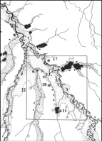
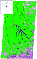 Fig. 1.
Upper Xingu region image [Landsat 7 Enhanced Thematic Mapper,
path 225, rows 68 to 69; 12 August 1999; image is a composite
false-color infrared with bands assigned as 5-4-3
(red-green-blue) to provide the appearance of natural
vegetation] with the approximate boundaries of the PIX and the
Kuikuro study area (inset of Upper Xingu, Brazil). The
ecological transition between the closed forests of southern
Amazonia and the more open savanna/gallery forest of the
Brazilian Planalto Central is shown (lower right). [View
Larger Version of this Image (88K GIF file)] Fig. 1.
Upper Xingu region image [Landsat 7 Enhanced Thematic Mapper,
path 225, rows 68 to 69; 12 August 1999; image is a composite
false-color infrared with bands assigned as 5-4-3
(red-green-blue) to provide the appearance of natural
vegetation] with the approximate boundaries of the PIX and the
Kuikuro study area (inset of Upper Xingu, Brazil). The
ecological transition between the closed forests of southern
Amazonia and the more open savanna/gallery forest of the
Brazilian Planalto Central is shown (lower right). [View
Larger Version of this Image (88K GIF file)]
|
In the Kuikuro study area (Fig.
2) (15),
19 major pre-Columbian settlements have been identified,
generally separated by 3 to 5 km and linked by a system
of broad, straight roads (16).
Recognition and mapping of major earthworks at these
sites reveal their articulation in a remarkably elaborate
regional plan (14).
The earthworks include (i) excavated ditches in and
around ancient settlements (up to 2.5 km long and 5 m
deep); (ii) linear mounds or "curbs" positioned at the
margins of major roads and circular plazas (averaging
about 0.5 to 1.0 m in height); and (iii) a variety of
wetland features, such as bridges, artificial river
obstructions and ponds, raised causeways, canals, and
other structures, many of which are still in use today.
Similar constructed features (such as settlements, roads,
weirs, and ponds) are known from culturally related
peoples (principally Arawak speakers) across the southern
Amazonian periphery (17–19)
[supporting online material (SOM) text].
The integrated settlement configuration was in place by c.
1250 to 1400 A.D., based on radiocarbon dates from
stratified deposits at X6, X11, and X13 (Table
1) (14,
20).
Major curbed roads (10 to 50 m wide) articulate with
plazas, ditches, and partition space within villages and
across the broader landscape, notably linking settlements
into "galactic" clusters across the region (21).
The Ipatse cluster includes four major residential settlements
(X6, X17, X18, and X22), linked to a fifth unfortified
"hub" site (X13), with only limited residential
occupation (Fig.
3A). Another cluster of sites, centered on X11, shows
a similar pattern of a large (50 ha) fortified settlement
connected to other smaller but still elaborate
settlements. In the case of the Kuhikugu (X11) cluster,
the largest residential center is the hub (Fig.
3B). The primary nodes of each cluster are also
linked by roads to smaller plaza settlements (fig. S1).
On the basis of artifact and dark-earth distributions, it
has been estimated that large sites, such as X6 and X11,
had 15 to 25 ha of residential space, medium sites (X17,
X18, X22) had 5 to 10 ha, and small sites had 2 to 5 ha
(14).
Thus, the actual residential area of a cluster like X6 or
X11 was at least 40 to 80 ha in an area of about 400
km2, with an estimated population of between 2500 and
5000 persons (or about 6 to 12.5 persons per
km2 in the study area).
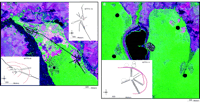 Fig. 3.
Satellite image [Landsat 4 Thematic Mapper, path 225, row 69;
21 June 1992; bands were assigned as 5(red)-4(green)-3(blue)]
with global positioning system–mapped Ipatse cluster sites X6
and X13 (A, insets) linked by the "north-south road"
and transit-mapped X11 (B, inset). Ditches are colored
in red; road and plaza curbs are black. Fieldwork in 2003
demonstrates that roads extend fully from X13 to X18, and
continue on to X19, X20, and beyond along the north-south
road, as well as across high ground to X17 and X22 (fig. S1);
X11 roads also connect it to the four satellites. MTFX, Mato
Grosso (the state), Formadores do Xingu (the archaeological
region). The number refers to the site number. [View
Larger Version of this Image (75K GIF file)] Fig. 3.
Satellite image [Landsat 4 Thematic Mapper, path 225, row 69;
21 June 1992; bands were assigned as 5(red)-4(green)-3(blue)]
with global positioning system–mapped Ipatse cluster sites X6
and X13 (A, insets) linked by the "north-south road"
and transit-mapped X11 (B, inset). Ditches are colored
in red; road and plaza curbs are black. Fieldwork in 2003
demonstrates that roads extend fully from X13 to X18, and
continue on to X19, X20, and beyond along the north-south
road, as well as across high ground to X17 and X22 (fig. S1);
X11 roads also connect it to the four satellites. MTFX, Mato
Grosso (the state), Formadores do Xingu (the archaeological
region). The number refers to the site number. [View
Larger Version of this Image (75K GIF file)]
|
Table 1. Radiocarbon dates from Nokugu
(X6) and other sites in the Kuikuro study area, southern
PIX. Beta 176135 to Beta 176144 are reported here for the
first time. Calibrated age ranges for samples dated in 2003
(numbered 176135 and up) were reported by Beta-Analytic
laboratory; previous (1994) dates were calibrated using
CALIB 4.0 (29).
ET, excavation trench of 1.0 by 10.0 m or more; EU,
excavation unit of 1.0 m2; S, southern side of
plaza or site; N, northern side; Ditch 1, outermost; Ditch
2, middle; Ditch 3, innermost ditch in all
sites.
| Lab no.
|
Site/unit
|
Conventional
radiocarbon |
2 -calibrated age range -calibrated age range
|
Provenance
|
|
Historical Xinguano (1700
A.D.—present)
|
| Beta 176142
|
X6/ET2
|
20 ± 50
|
modern*
|
Ditch 3 (S), upper
ditch infill |
| Beta 72260
|
X6/ET1
|
180 ± 60
|
1520-1940 A.D.
|
Ditch 2 (S), upper
ditch infill |
Terminal "galactic" period
(1400-1700 A.D.)
|
| Beta 176137
|
X6/ET10
|
340 ± 60
|
1460-1640 A.D.
|
Ditch 2 (N), upper
ditch infill |
| Beta 81301
|
X6/ET1
|
360 ± 70
|
1420-1640 A.D.
|
Ditch 2 (S),
mid-ditch infill |
| Beta 176135
|
X6/ET3
|
440 ± 60
|
1420-1480 A.D.
|
Small plaza, subcurb
intact |
| Beta 72262
|
X11/EU1
|
440 ± 70
|
1400-1650 A.D.
|
North road,
intact/curb interface
|
| Beta 176140
|
X6/ET3
|
530 ± 60
|
1400-1430 A.D.
|
Small plaza, subcurb
intact |
Initial "galactic" period
(1250-1400 A.D.)
|
Beta 176139 |
X6/ET2
|
590 ± 60
|
1300-1420 A.D.
|
Ditch 3 (N), basal
fill |
| Beta 177724 |
X6/ET2
|
670 ± 60
|
1260-1410 A.D.
|
Ditch 3 (N), basal
fill |
| Beta 88362
|
X13/EU1
|
690 ± 60
|
1260-1300 A.D.
|
Central plaza,
subcurb intact |
| Beta 78979
|
X6/ET1
|
700 ± 70
|
1230-1410 A.D.
|
Ditch 2 (S),
sub-berm intact |
| Beta 176136
|
X6/ET4
|
710 ± 50
|
1270-1300 A.D.
|
Ditch 1 (S), basal
fill |
Late
developmental (900-1250 A.D.)
|
| Beta 72263
|
X11/EU1
|
900 ± 60
|
1000-1250 A.D.
|
North road, subcurb,
basal intact |
| Beta 88363
|
X13/EU1
|
910 ± 80
|
1040-1250 A.D.
|
Central plaza,
subcurb base intact |
| Beta 72261
|
X6/ET1
|
1000 ± 70
|
950-1210 A.D.
|
Ditch 2 (S),
sub-berm, base intact
|
| Beta 176141
|
X6/ET5 1
|
030 ± 60
|
980-1030 A.D.
|
Central plaza,
subcurb base intact |
Initial Xinguano (pre-900 A.D.)
|
| Beta 176143 |
X6/ET2
|
1370 ± 60
|
640-690 A.D.
|
Mid-ditch 3 (N),
mid-ditch |
Beta 176138
|
X6/ET10
|
2110 ± 40
|
190-60 B.C.
|
Ditch (N), basal
fill
| |
* Two additional
modern dates, Beta 98978 and Beta 176144, are considered
invalid. The former was redated with a sample slightly
higher in profile (Beta 81301).
Beta 176139 is inversed with 176143 and
was redated by 177724. Beta 176138 also comes from
stratified but mixed context of ditch infill, and both
likely represent earlier materials that are mixed in
ditch construction.
| |
Areas within each galactic cluster can be characterized as
saturated anthropogenic landscapes, because virtually the
entire area in and between major settlements, although
not entirely cultural in origin, was carefully engineered
and managed. Indeed, the road networks, oriented by the
same system of cardinality that characterizes plaza
spatial organization, partitioned the landscape into a
gridlike or latticelike organization of nodes (plazas)
and connecting thoroughfares, although patches and
corridors of secondary and perhaps managed forests were
likely common, as they are today. Mapped archaeological
features correspond to patches of acutely modified
secondary growth, distinctive from surrounding forest and
easy to recognize in satellite images. These patches or
islands are identified in the indigenous knowledge
systems, including diverse species whose distributions are
generally restricted to anthrosols (dark earth)—called
egepe by the Kuikuro—associated with ancient settlements
(22–24)
(SOM text). Some areas related to major pre-Columbian
settlements, like X6, X11, and X13, have not returned to
high forest after about 400 years of abandonment,
although other areas (such as roads, hamlets, gardens,
fields, and parklands) show a highly patchy forest
regrowth typical of postabandonment (after 1600 to 1750)
succession.
Recognition of the massive forest alterations associated
with pre-Columbian occupations requires an understanding
of local biodiversity in the context of the complex
cultural history of the area. The composition of forest
and wetland habitats reflects long-term cumulative
changes, given that the settlement areas were occupied
more or less continuously over many generations, as well
as the large-scale alteration and management of local
environments by dense late-prehistoric occupations (c.
1250 to 1650 A.D.). Present soil and biotic
distributions, often isomorphic with the distribution of
archaeological features, notably plazas, residential
areas, roads, and road-side hamlets, are in large part
the result of pre-Columbian land-management strategies.
After c. 1600 to 1700, catastrophic depopulation (25)
led to the abandonment of these works and many settlements,
resulting in extensive reforestation in many areas. The
scale of the prehistoric settlements, including exterior
constructions, such as roads, hamlets, wetland
structures, and cultivation areas, suggests that
agricultural and parkland landscapes, rather than high
forest, characterized the broad landscapes around ancient
villages, as is true in contemporary villages. Metal
technology, however, has increased the speed at which
forests can be converted into mosaic parklands of
dispersed manioc gardens, sapé grass fields, piqui
groves, and secondary forests (26)
(Fig.
4).
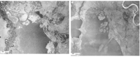 Fig. 4.
Aerial photographs (U.S. Air Force/Força Aérea Brasileira
1967; 1: 60,000) of Lake Ipatse (A) and Lake Kuhikugu
(B) showing land-cover change during 6-year period
(1961 to 1967) after abandonment (Kuhikugu) and reoccupation
(Ipatse). Comparison with Fig.
3 (1992) of same areas shows an Fig. 4.
Aerial photographs (U.S. Air Force/Força Aérea Brasileira
1967; 1: 60,000) of Lake Ipatse (A) and Lake Kuhikugu
(B) showing land-cover change during 6-year period
(1961 to 1967) after abandonment (Kuhikugu) and reoccupation
(Ipatse). Comparison with Fig.
3 (1992) of same areas shows an  30-year period. Graphic testimony of post-1492
decline in village size is shown by comparing the size of X11
with the four sequential Kuikuro villages (c. 1870s to 1961)
in and north of the ancient site and by comparing X6 with the
active village in 1967 and 1992. [View
Larger Version of this Image (77K GIF file)] 30-year period. Graphic testimony of post-1492
decline in village size is shown by comparing the size of X11
with the four sequential Kuikuro villages (c. 1870s to 1961)
in and north of the ancient site and by comparing X6 with the
active village in 1967 and 1992. [View
Larger Version of this Image (77K GIF file)]
|
The Upper Xingu is a unique Amazonian example of a tropical
forest way of life that supported large, densely settled,
and integrated regional populations over the past 1000
years. Local ecology reflects the dynamic interaction
between the natural environment, the influence of fairly
large, settled human populations, and the legacy of
Euro-American colonialism over the past 500
years. Evidence of large, well-engineered public works
(such as plazas, roads, moats, and bridges) in and
between pre-Columbian settlements suggests a highly
elaborate built environment, rivaling that of many
contemporary complex societies of the Americas and
elsewhere (SOM text). To suggest that Xinguano lands were
intensively managed and developed, c. 1492, however, does
not imply that indigenous land-use strategies, based on
patchy development within long rotational cycles, are
comparable to modern nonindigenous clear-cutting
strategies (27,
28).
Xinguano cultivation and land management, indeed,
provides a viable alternative. The present research
emphasizes the critical importance of collaborative
research strategies, including archaeological and
ethnographic fieldwork, remote-sensed data analysis and
geographic information systems, and most important,
indigenous participation, to understand the complex
interplay of ecological, historical, and political
conditions in Amazonia before and after 1492.
References and
Notes
| 1. |
W. Balee, Econ. Bot.
7, 1 (1989). |
| 2. |
W. Denevan, Ann. Assoc. Am.
Geog. 82, 369 (1992).[ISI] |
| 3. |
D. Lathrap, The Upper Amazon
(Praeger, London, 1970). |
| 4. |
C. Mann, Science 287,
786 (2000).[Free Full Text] |
| 5. |
C. Mann, Atlantic Monthly
2001, 41 (March 2002). |
| 6. |
This theory has been widely
disseminated in popular media [e.g., "Fertile secret: How did
ancient Amazonians turn sand into rich soil? Garbage,"
American Broadcasting Corporation, 19 September 2002,
available online on http://abcnews.go.com/sections/scitech/DyeHard/dyehard020919.html;
and "The secret of El Dorado," British Broadcasting
Corporation, 19 December 2002, available online on www.bbc-.co.uk/science/horizon/2002/eldorado.shtml. |
| 7. |
A. C. Roosevelt, Am. Anthropol.
Assoc. Pap. 9 (1999), pp. 13–33. |
| 8. |
M. J. Heckenberger, J. B. Petersen,
E. G. Neves, Lat. Am. Antiq. 10, 353 (1999).[ISI] |
| 9. |
R. Carneiro, Subsistence and
Social Structure (Univ. of Michigan Press, Ann Arbor,
1957). |
| 10. |
R. Carneiro, in Adaptive
Responses of Native Amazonians, R. Hames, W. Vickers. Eds.
(Academic Press, New York, 1983), pp. 65–111. |
| 11. |
M. Heckenberger, Antiquity
72, 633
(1998).[ISI] |
| 12. |
Initial Xinguano occupations date
sometime between 200 B.C. and 800 A.D., but the exact date is
uncertain because the two earliest radiocarbon dates are from
mixed deposits, and in one case (Beta-Analytic Laboratory
number 176143) the dates are demonstrably out of sequence. |
| 13. |
Manioc, fish, and piqui fruit
constitute 90% or more of the diet (9). |
| 14. |
Materials and methods are available
as supporting material on Science Online. |
| 15. |
The Kuikuro study area is about the
same as the Kuikuro (Carib Xinguano) traditional territory. It
is about 1000 km2 and is located in an area of
traditional Xinguano occupations that is 25,000 to 35,000
km2. |
| 16. |
Several additional large sites are
known in the study area, on the basis of indigenous knowledge
of dark-earth locations, and numerous smaller occupation sites
are also known, including small road-side hamlets along the
major roads. |
| 17. |
A. Metraux, BAE, Bulletin 143
(Smithsonian Institution, Washington, DC, 1948), vol. 3, pp.
349–360. |
| 18. |
C. Erickson, Nature
408, 190
(2000).[CrossRef][ISI][Medline] |
| 19. |
M. Heckenberger, in Comparative
Arawak Histories: Rethinking Culture Area and Language
Group, J. Hill, F. Santos-Granero, Eds. (Univ. of Illinois
Press, Urbana, 2001), pp. 99–122. |
| 20. |
Here, "galactic" describes the
regional site clusters organized around a center or hub (X11
and X13), with several major residential sites connected to
it. |
| 21. |
S. Tambiah, Ritual, Performance,
and Thought (Harvard Univ. Press, Cambridge, MA, 1985). |
| 22. |
Dark earth forms in compost areas,
although widespread burning produces minor but extensive soil
alterations. |
| 23. |
W. I. Woods, J. McCann, Yearb.
Conf. Lat. Am. Geogr. 25, 7 (1999). |
| 24. |
J. B. Petersen, E. G. Neves, M. J.
Heckenberger, in The Unknown Amazon, C. McEwan, E.
Neves, C. Barreto, Eds. (British Museum Press, London, 2001),
pp. 86–105. |
| 25. |
M. Heckenberger, in Os Povos
Indígenas do Alto Xingu: História e Cultura, B.
Franchetto, M. Heckenberger, Eds., [Editora Universidade
Federal do Rio de Janeiro (UFRJ), Rio de Janeiro, 2001], pp.
77–110. |
| 26. |
W. Denevan, J. Steward Anthropol.
Assoc. 20, 153 (1992). |
| 27. |
W. Denevan, Cultivated Landscapes
of Native Amazonia and the Andes (Oxford Univ. Press, New
York, 2001). |
| 28. |
N. Smith, A. Serraão, P. Alvim, I.
Falesi, Amazonia: Resiliencyand Dynamism of a Land and Its
People (United Nations Press, Tokyo, 1995). |
| 29. |
M. Stuiver, G. W. Pearson.,
Radiocarbon 35, 1 (1993).[ISI] |
| 30. |
Ethnoarchaeological research in the
Upper Xingu by M.J.H., conducted in collaboration with the
Museu Nacional (UFRJ), the Museu Goeldi, and the Kuikuro
community, has been ongoing since 1991; 2001 to 2003 fieldwork
was supported by NSF grant Behavioral and Cognitive Sciences
no. 0004487 (2001 to 2003). We thank A. Melges, J. Petersen,
and W. Hillman for their support. |
Supporting Online Material
www.sciencemag.org/cgi/content/full/301/5640/1710/DC1
Materials and Methods
SOM Text
Fig. S1
References
Movie S1
25 April 2003; accepted 25 July
2003
10.1126/science.1086112
Include this information when
citing this paper.
Volume 301, Number 5640, Issue of 19 Sep 2003,
pp. 1710-1714.
Copyright © 2003 by The American Association for the
Advancement of Science. All rights reserved.
|