 Belchertown, Hardwik, Shutesbury, and New Salem were also taken for the
reservoir and its protected watershed.
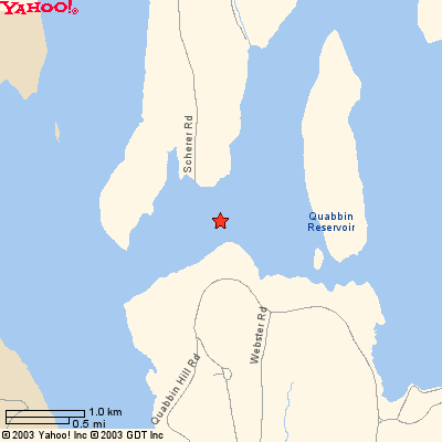
A map showing where Enfield was located (the red star) and of the
area including the reservoir can be seen below.
Belchertown, Hardwik, Shutesbury, and New Salem were also taken for the
reservoir and its protected watershed.
A map showing where Enfield was located (the red star) and of the
area including the reservoir can be seen below.
The State of Massachusetts took the Quabbin Valley by eminent domain to build a reservoir. The rapidly growing population in and around Boston had exhausted local fresh water supplies. A number of villages were doomed in full or part by this action.
Enfield and Greenwich would be completely covered by water. Parts of
Belchertown, Hardwik, Shutesbury, and New Salem were also taken for the
reservoir and its protected watershed.
A map showing where Enfield was located (the red star) and of the
area including the reservoir can be seen below.
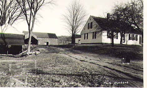
In Enfield, Alice L. Bolter owned the classic Cape Code-style home shown at the right. A hand-drawn map showing the house is in the lower-left corner of the photo. The road heading west-north-west goes to Enfield center; heading east-southeast, it goes to Ware. Official property data is included on a sign shown on the lawn below the front door.
It was originally built in 1767. In 1817, the home was purchased by Captain Lombard. He did general shipping, sailing the William Gray out of Boston to points as far south as Florida. The Hampden County Record's Office contains more detail on the life of this house. Those records officially refer to "The Captain Lombard House."
 Return to the thumbnail photos.
 Yahoo's on-line map that may be zoomed out to show the
location of Enfield relative to Amherst (southeast), and Amherst in
the state of Massachusettes (west central) can be opened by clicking
here.
Yahoo's on-line map that may be zoomed out to show the
location of Enfield relative to Amherst (southeast), and Amherst in
the state of Massachusettes (west central) can be opened by clicking
here.